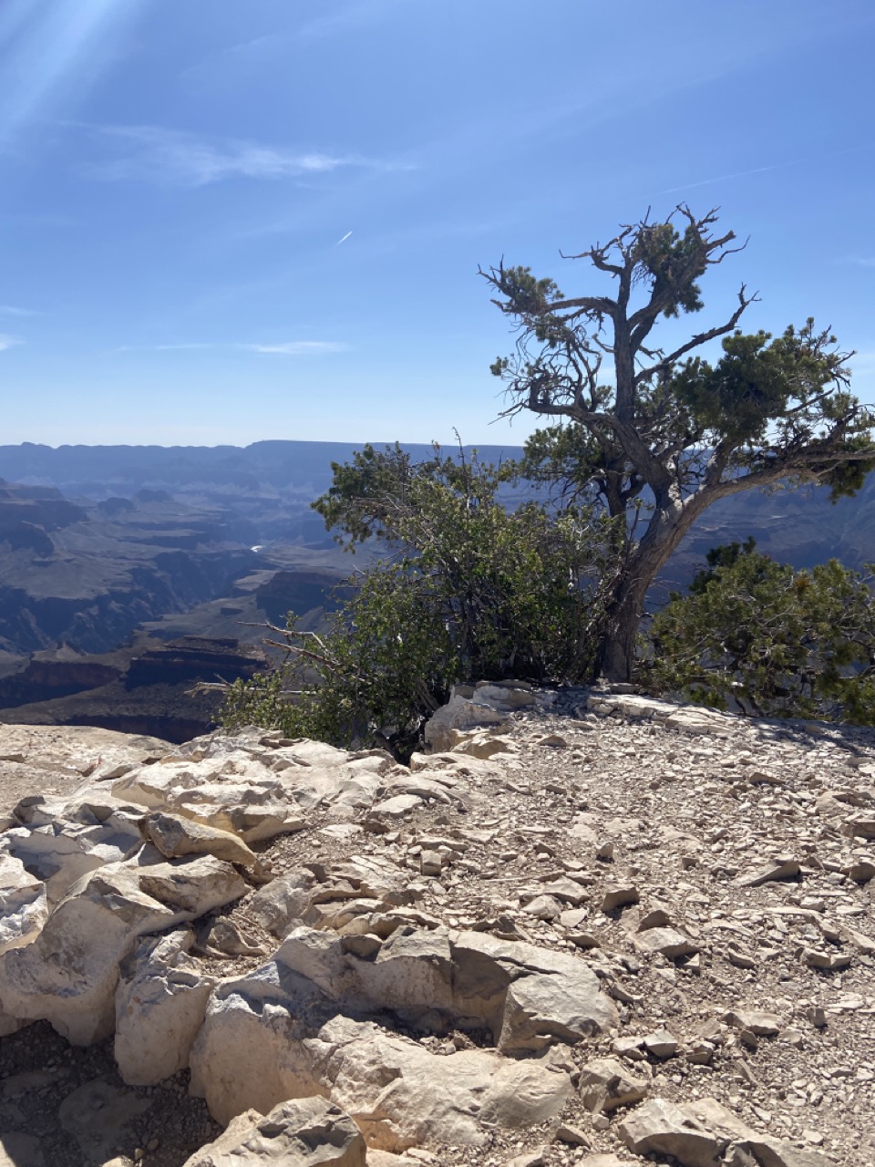
Where does one start when writing about the Grand Canyon? Would giving its vital statistics help visualise its enormity? Would pictures capture its beauty? Is seeing believing? Honestly, I was mesmerised by the landscape and spellbound by what nature can do as it metamorphosed over millions of years. It was initially called Big Canyon, and indeed, the re-christening was required; the place is really GRAND!
The Grand Canyon is not the largest in the world; that credit goes to Yarlung Tsangpo Canyon in Tibet. However, it is a one-stop lesson in geography. The canyon was shaped by erosion and other climatic conditions over 5 million years, exposing rocks as old as 2 billion years. These rocks are stacked neatly, one above the other, and the different types of rocks from different eons add to the colour-scape of the canyon. Not to forget the Colorado River that runs deep down in the canyon today.
After meandering along the route from Sedona to Grand Canyon, we checked into our hotel in Tusayan, a small town just outside Grand Canyon National Park (the lodges inside the park fill up months ahead!). Like most visitors, our plan was to visit the South Rim of the canyon.
On the South Rim, there are over 50 viewpoints from east to west. Some of them are located right on the rim and are crowded because these overlooks do not require hiking. Viewpoints that are a short hike away are less crowded. These stops offer different vistas – sometimes you see the same set of rocks from a different angle, sometimes you see different formations, sometimes you see a bit of the river, and sometimes the trails that lead down to the river.
On our first evening, we drove to Desert Viewpoint in the east to catch the sunset on the Canyon. This is one of the places where the Colorado river is visible as it snakes along. The 300 feet wide river looks like a stream from the viewpoint! Aeroplanes flying nearby used to veer off the flight path to glimpse the canyons below. This illegal practice stopped after a tragic mid-air collision and gave ground to establishing the U.S Federal Aviation Authority.

There is a watchtower here, a modern building that serves as an observation deck and houses a gift shop. It was built using local elements to blend in with the surroundings. It was closed at the time of my visit.

The next day we decided to hike the easy Shoshone Trail, a short 3.5 km round trip that offers fantastic views of the east side of the canyon.

In the far distance, we could see a sliver of the river.
Following that we went to the Visitor Centre, watched a short video on the formation of the canyon and walked over to Mather Point, the viewpoint closest to the visitor centre, therefore very very popular (which also means crowded). The canyon’s north rim is 10 miles across from here! And yet again, we caught a tiny glimpse of the mighty Colorado river!

We walked further west along the rim trail to Yavapai Point where the museum was one of the first interpretation centres at the Grand Canyon National Park. From here, you can see the first ever 400-feet suspension bridge built across the Colorado river in hundreds of river miles of its run and remains one of the few crossings across the river!

After all that walking, we could each eat a horse. Like any national park, here, too, food options are minimal, far out and meh. Not sure if it was because we were hungry or the food was really good, but we quite enjoyed our meal at the Yavapai Tavern, located close to the Grand Canyon Village Market & Deli and a short drive from the car park at the visitor centre. In fact, we went back there for a meal the next day, and the food was just as good – it was not hungry people eating whatever!
After a short break in the afternoon, we were back on Desert View Road and this time, we saw the ‘Duck on a rock’ formation and tried once again to catch the sunset at different locations. The play of light on rocks of different colours makes it a very surreal experience.

As we were driving from one point to another, we encountered a herd of elks and couldn’t help but stop and watch them in fascination, just like tourists who visit India are fascinated by herds of deer in our national parks and cows on our roads. Elks can be aggressive, but the title for the most aggressive animal in the Grand Canyon National Park goes to the rock squirrels. They are so cute that tourists tend to feed them, and they have got used to that now. The squirrels literally demand food and dare to rummage through bags; the American equivalent of the Indian monkeys 😊

On our last day at the Grand Canyon, just like in Sedona, the ones without weak knees hiked the Bright Angel Trail.
This is a very popular hike and one of the more accessible trails down into the canyon. It is ideal for a day hike only if you have high levels of strength and stamina. Otherwise, you can opt to hike short sections. The walk back up to the rim is very steep and can take twice as long as it takes to go down!

In the evening, we were out again covering the lookout points west of the Visitor Centre. Pima point needs special mention as here you can ACTUALLY hear the river rapids from below as does Hermit’s Rest which is the last stop on the rim trail.

The structure at Hermit’s Rest, resembling a miner’s cabin, was built by the same architect (Mary Colter) who built the watch tower at Desert View Point. Today it serves as a gift shop and snack bar.

Our next stop was the Trail of Time where every metre you walk signifies a million years with rocks and info boards that explain the geologic formations of the canyon. Besides all the gyaan, it was a good place to view our last sunset in the Canyon without the crowds; in fact it was just us. We stood in silence and watched the sun disappear behind the north rim. It was a fitting end to the trip to the Grand Canyon.

The formations in the canyon resemble battleships, temples, pyramids and are named as such (Vishnu Temple, Coronado Butte, Isis Pyramid).

All one needs to do is let the imagination fly to see similarities between man-made structures and those formed by nature. At these overlooks, the North Rim is visible like a flat table at the far end! Since it is not as accessible, far fewer visitors choose the North Rim over the South Rim.

The Grand Canyon appears vast and limitless and in that lies its power of allurement. Can I sum it up in one word? STUPENDOUS!!! What did you feel when you visited the Grand Canyon?
